• Welcome to Baptist Board, a friendly forum to discuss the Baptist Faith in a friendly surrounding.

    Your voice is missing! You will need to register to get access to all the features that our community has to offer.

    We hope to see you as a part of our community soon and God Bless!

The Flood of waters.

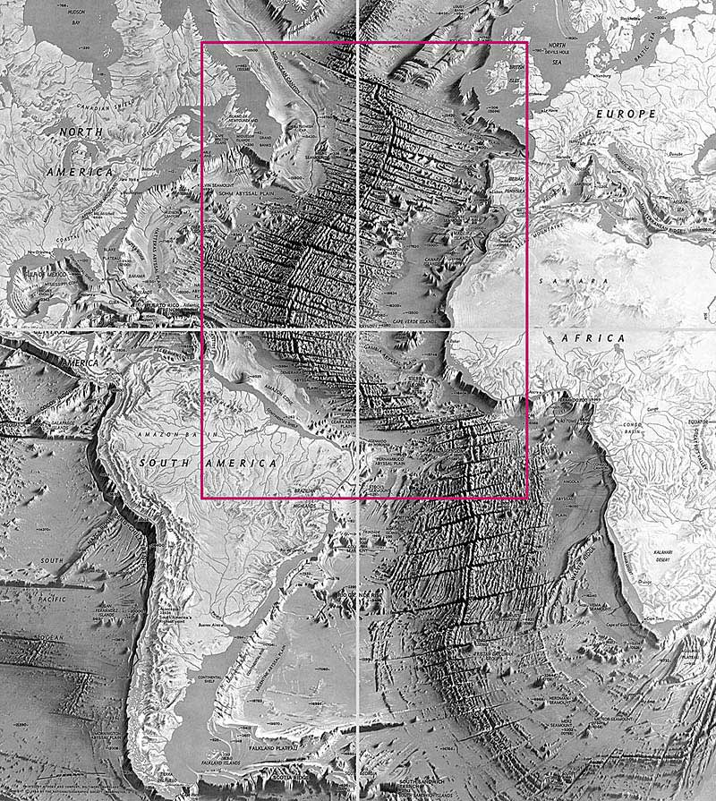
This map shows that in the history of the Earth there was the cubic dilatation, and "the dry land " (Gen. 1:10) which was called "Earth" was broken on parts. When did it happen?

DURE6.JPG
 

Marooncat79

Well-Known Member
Site Supporter
Seemingly, Mountain bldg and continent separation happened either during or just after the flood.

Thats what makes the most sense to me. JMO

Hope this helps?
 
As you can see on the map, the contours of the shelf of South America and Africa completely coincide. These continents were one before the Flood.
 

canadyjd

Well-Known Member
As you can see on the map, the contours of the shelf of South America and Africa completely coincide. These continents were one before the Flood.
The contours of the shelf of South America and Africa sort of coincide or generally coincide. They do not “completely” coincide. If it were a puzzle, it wouldn’t fit exactly.

peace to you
 

JonC

Moderator
Moderator
As you can see on the map, the contours of the shelf of South America and Africa completely coincide. These continents were one before the Flood.
The problem with examining the contours is that natural sea erosion would also accomplish the same thing (in a relatively short amount of time). I'm not saying I disagree with you (I've thought the same thing) but there are other reasonable explanations.
 
The problem with examining the contours is that natural sea erosion would also accomplish the same thing (in a relatively short amount of time). I'm not saying I disagree with you (I've thought the same thing) but there are other reasonable explanations.
According to scientists, the total area of the continental shelf of the world's ocean is about 32 million square kilometers.

Total area of the Earth: 510 072 000 sq.km.

Land: 148,940,000 square kilometers

Water: 361 132 000 square kilometers

Attention: 70.9% of the surface of the globe is occupied by water, 29.1% by land

The land area and continental shelf area are in total 170,940,000 square kilometers

The radius of the Earth, which is now equal to 6371 km

We can easily determine the radius of the Earth that was before the flood:

r = (170940000x6371): 510072000 = 3700 km

We can compare the radius of the Earth, which it had before the flood with the radius of the Earth, which is now:

r = 3700km; R = 6371km

I think the error in the calculations is within a statistical error. That is about 3%

The formation of continents during the Flood can be seen here

 
Last edited:

church mouse guy

Well-Known Member
Site Supporter
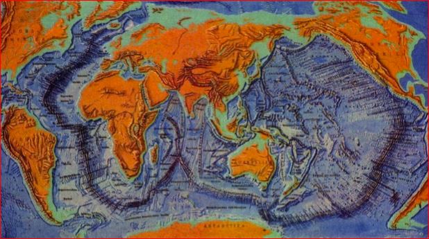
The seams at the bottom of the ocean, discovered and mapped after World War II, are where the fountains of the deep broke open. The continents, as you know, are floating chunks of land and they were moving about at great speed and collided with each other and broke apart into the current formations at the end of Noah's Flood. American education adopted the geological thinking of Europe, which emphasized gradualism or naturalism after the founder of geology Hutton and after British lawyer Lyell, who wrote the books on geology that Darwin read on his long voyage. The philosophical viewpoint of American geology is to deny catastrophes such as Noah's Flood and support old earth or deep time thinking. Hence, American geology has a difficult time explaining the seams at the bottom of the ocean and stalls on many other clear evidences of Noah's Flood while clinging stubbornly to deep time which daily has new scientific challenges to it. However, God has covered the earth with the debris of Noah's Flood and scars such as the bottom of the ocean have to show the catastrophic effects of sin upon man and the universe. American science grows more and more backward and it is doubtful to me that it will ever correct itself. We came to world power by wealth and military might and not by scientific knowledge or education. The Founding Fathers left us a sophisticated republic easily battered by greed and ignorance. As we pursue the naturalistic science of the Enlightenment to a dead end, it seems that we also pursue the political French Revolution of the Enlightenment to a dead end.
 

JonC

Moderator
Moderator
According to scientists, the total area of the continental shelf of the world's ocean is about 32 million square kilometers.

Total area of the Earth: 510 072 000 sq.km.

Land: 148,940,000 square kilometers

Water: 361 132 000 square kilometers

Attention: 70.9% of the surface of the globe is occupied by water, 29.1% by land

The land area and continental shelf area are in total 170,940,000 square kilometers

The radius of the Earth, which is now equal to 6371 km

We can easily determine the radius of the Earth that was before the flood:

r = (170940000x6371): 510072000 = 3700 km

We can compare the radius of the Earth, which it had before the flood with the radius of the Earth, which is now:

r = 3700km; R = 6371km

I think the error in the calculations is within a statistical error. That is about 3%

The formation of continents during the Flood can be seen here

I'm not a scientist. I know the water part is wet. That is the extent of my expertise.
 

church mouse guy

Well-Known Member
Site Supporter
I'm not a scientist. I know the water part is wet. That is the extent of my expertise.

The bottom of the ocean took on the current form about 4300 years ago. It is a reminder of what man's sin caused. The surface of the land is mostly the graveyard of the life killed by the Flood and another reminder of the results of man's sin.
 
  • Like
Reactions: Sai
The seams at the bottom of the ocean, discovered and mapped after World War II, are where the fountains of the deep broke open. The continents, as you know, are floating chunks of land and they were moving about at great speed and collided with each other and broke apart into the current formations at the end of Noah's Flood. American education adopted the geological thinking of Europe, which emphasized gradualism or naturalism after the founder of geology Hutton and after British lawyer Lyell, who wrote the books on geology that Darwin read on his long voyage. The philosophical viewpoint of American geology is to deny catastrophes such as Noah's Flood and support old earth or deep time thinking. Hence, American geology has a difficult time explaining the seams at the bottom of the ocean and stalls on many other clear evidences of Noah's Flood while clinging stubbornly to deep time which daily has new scientific challenges to it. However, God has covered the earth with the debris of Noah's Flood and scars such as the bottom of the ocean have to show the catastrophic effects of sin upon man and the universe. American science grows more and more backward and it is doubtful to me that it will ever correct itself. We came to world power by wealth and military might and not by scientific knowledge or education. The Founding Fathers left us a sophisticated republic easily battered by greed and ignorance. As we pursue the naturalistic science of the Enlightenment to a dead end, it seems that we also pursue the political French Revolution of the Enlightenment to a dead end.
Yes.
Notice, at first "all the fountains of the great deep" (Gen.7:11) were broken up. Billions of tons of hot lava began to fly in the atmosphere because there were the explosions of water vapor. The upper part of the mid-Atlantic ridge was precisely this line of rupture. As we see in the map, this line repeats the contours of South America and Africa. When the pressure of hot magma, mixed with water vapor, split the dry land, which was called Earth on four smaller continents, hot magma, mixed with hot steam, flowed from these cracks. The density of the Earth's matter began to decrease rapidly, and the volume of the Earth was also increasing rapidly, the newly formed continents began to swim across the surface of the swelling Earth. The water vapor began to condense in the atmosphere, and dissolve the ice shell of the Earth so "the windows of heaven were opened" (Gen.7:11) and it began to rain. As the water on the Earth became more and more, explosions of hot water vapor began to occur not in the atmosphere, but under water. A lava flowed from the mid-Atlantic ridge even under water. The greatest activity of the chemical reaction within the Earth lasted one hundred and fifty days, so "the waters prevailed upon the earth an hundred and fifty days" (Gen.7:24).

The bottom of the oceans is the new surface of the Earth that appeared during the Flood. The thickness of the bottom of the oceans is, on average, 10 km, the thickness of the continents is tens of times greater.
 
“Scientists have modeled the conditions that are characteristic of the bowels of the Earth, in particular, a temperature of about 1.4 thousand degrees Celsius and a pressure 20 thousand times greater than at the surface of the planet. With these parameters, silicon dioxide contained in the mantle undergoes a chemical reaction with hydrogen, which leads to the formation of water and silicon hydride.”

The water formed at great depths as a result of this chemical reaction was rushing to the Earth's surface due to the difference in its density and the density of the surrounding magma. At a certain depth, the water from the liquid phase was passing into a gaseous state. In other words, there was an explosion. Millions of tons of hot lava mixed with superheated (1400 degrees Celsius) steam were emitting into the atmosphere from the faults. At the same time, the split parts of the Earth were spreading in different directions on the swelling Earth ...

Read more: The Flood of waters. - Christianity -  - Page 2 - City-Data Forum
 

Salty

20,000 Posts Club
Administrator
The contours of the shelf of South America and Africa sort of coincide or generally coincide. They do not “completely” coincide. If it were a puzzle, it wouldn’t fit exactly.

peace to you


close enough for govt work
 
The contours of the shelf of South America and Africa sort of coincide or generally coincide. They do not “completely” coincide. If it were a puzzle, it wouldn’t fit exactly.

peace to you

1200px-Antarctica_on_the_globe_%28grey%29.svg.png


scale_1200


scale_1200


Part of the contour of the Australian shelf and part of the contour of the Antarctic shelf also coincide. This proves that these two continents in the past were one whole. Children can fold this puzzle easily. In adults it is worse.
 
Top